UTM-CSIC Catalogue
TASMANDRAKE
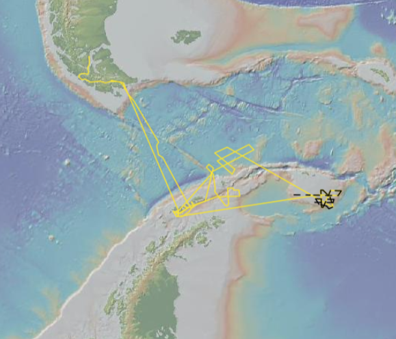
The general objective of the TASMANDRAKE project is the study of the onset and evolution of the Antarctic Circumpolar Current (ACC). Taking into account the allowed period and that the capabilities of the geophysical equipment on board cannot image the deep structures and sediments, the cruise cannot fulfill the objectives of the TASMANDRAKE Project pertaining to the opening of gateways and onset of the ACC. We have therefore developed and alternative plan for the DRAKE2018 cruise that will allow us to collect mid-penetration to shallow data from the southern Drake-Scotia area (58ºS/62ºS and 60ºW/50ºW) and the South Orkney Shelf (60ºS/63ºS and 50ºW/40ºW). With this kind of capabilities we target those objectives of the TASMANDRAKE Project dealing with: 1) the evolution of the ACC during the Pleistocene and the Holocene; and 2) near-surface structure of continental blocks (i.e., the South Orkney micro-continent and the platform surrounding Elephant Island) and age of the older oceanic crust in Drake Passage. The proposed work is aimed to help land- ocean correlations between the stratigraphy of Seymour/Marambio Island and Ocean Drilling Project Site 696, in order to better understand the break-up and paleogeographic evolution of these continental blocks. The proposed marine surveys will consist in the execution of predefined transects along which geophysical data will be collected. In addition, we expect to collect sediment cores in specific sites, in order to groundtruth seismic facies with sediment information and provide age constrains of the most recent (Quaternary-Pliocene) units.
Simple
- Alternate title
-
29HE20180111
- Date (Revision)
- 2018-01-11
- Citation identifier
- urn:SDN:CSR:LOCAL:29HE20180111
- Cited responsible party
-
Organisation name Individual name Electronic mail address Role IGME, Geological Survey of Spain
Originator IACT-UGR-CSIC, Andalusian Earth Sciences Institute
Originator CSIC-UTM/ Marine Technology Unit
Originator
- Point of contact
-
Organisation name Individual name Electronic mail address Role IGME, Geological Survey of Spain
Bohoyo Muñoz, Fernando
Point of contact IACT-UGR-CSIC, Andalusian Earth Sciences Institute
Escutia Dotti, Carlota
Point of contact
-
Port of Departure
-
-
Ushuaia
-
-
Port of Departure
-
-
Punta Arenas
-
-
Port of Departure (country)
-
-
Argentina
-
-
Port of Departure (country)
-
-
Chile
-
-
Platform/Ship
-
-
Hesperides
-
-
Platform type
-
-
research vessel
-
-
Geographic Areas
-
-
South Atlantic Ocean
-
Drake Passage
-
Scotia Sea
-
-
Parameters measured
-
-
Bathymetry and Elevation
-
Gravity
-
Seismic reflection
-
Two-dimensional seismic reflection
-
Magnetics
-
Acoustic backscatter in the water column
-
Sound velocity and travel time in the water column
-
Sedimentary structure
-
Air pressure
-
Air temperature
-
Atmospheric humidity
-
Solar Radiation
-
Horizontal spatial co-ordinates
-
Sediment acoustics
-
Sediment age
-
Raw temperature and/or salinity instrument output
-
-
Instruments used
-
-
gravimeters
-
magnetometers
-
multi-beam echosounders
-
single-beam echosounders
-
Sparker
-
>2000 Hz top-bandwidth sub-bottom penetrator and mud profiler systems
-
hydrophones
-
NAVSTAR Global Positioning System receivers
-
unconsolidated sediment corers
-
meteorological packages
-
thermosalinographs
-
multi-channel seismic reflection systems
-
bathythermographs
-
- Character set
- UTF8
- Topic category
-
- Marine Geology
Extent
))

- Geographic identifier
- Antarctic Ocean
Temporal Extent
- Topic category
-
- Marine Geology
- Begin date
- 2018-01-11T00:00:00
- End date
- 2018-02-14T00:00:00
- OnLine resource
-
Protocol Linkage Name WWW:LINK-1.0-http--link
http://data.utm.csic.es/set/hes/20180111/cite DOI CITATION: 10.20351/29HE20180111
WWW:LINK-1.0-http--link
http://data.utm.csic.es/set/hes/20180111/doc DOCUMENTATION
WWW:LINK-1.0-http--link
http://data.utm.csic.es/set/hes/20180111/open OPEN DATA
WWW:LINK-1.0-http--link
http://data.utm.csic.es/set/hes/20180111/map CRUISE MAP
- Hierarchy level
- Cruises
Conformance result
- Title
-
COMMISSION REGULATION (EC) No 1205/2008 of 3 December 2008 implementing Directive 2007/2/EC of the European Parliament and of the Council as regards metadata
- Date (Publication)
- 2008-12-04
- Explanation
-
See the referenced specification
- Pass
- Yes
- Statement
-
The data centres apply standard data quality control procedures on all data that the centres manage. Ask the data centre for details.
Metadata
- File identifier
- urn:SDN:CSR:LOCAL:29HE20180111 XML
- Character set
- UTF8
- Hierarchy level
- Cruises
- Hierarchy level name
-
Cruise Summary record
- Date stamp
- 2025-03-28T12:12:09.414Z
- Metadata standard name
-
ISO 19115:2003/19139
- Metadata standard version
-
1.0
- Metadata author
-
Organisation name Individual name Electronic mail address Role CSIC-UTM/ Marine Technology Unit
Point of contact